Researcher : Dr. Anna Brook
Background
An understanding of the spatial multi-scale relationships in any given environment, e.g., natural ecosystems, agriculture or marine environment, is an important step for management and decision-making. The set of required parameters and properties for understanding these spatial relationships are termed as essential aspects. Nowadays, many available approaches capture some aspects but each method comes with its own limitations.
Advancing Multi-Source Remote Sensing for Environmental and Ecological Study and Agricultural Improvement
Dr. Anna Brook, head of the University of Haifa's Remote Sensing Laboratory in the Department of Geography and Environmental Studies, is focusing her research on development and implementation of advanced remote sensing methods and techniques for environment and ecological studies, emphasizing the importance of multi-source data fusion.
Their work aims to generate a monitoring system based on integrative fusion of multi-source remote sensing spatial/spectral data enlarging the application envelope of each individual technology and contributing valuable and unique information. This practical system is providing the interdisciplinary scientific community with tools to consider fully integrated multi-source data (qualitative and quantitative spectral/thermal/spatial/temporal and 3-D information) for environmental applications.
Research Status
Dr. Brook and her research team are developing a new approach that is integrating environmental descriptive methods designed for operating at specific spatial and temporal resolutions. Their goal is to identify features related to chemical, physical, morphological and textural variations at different spatial (single field – district) and temporal scale (daily – weekly) and integrate them with a multi-scale information system.
Integration of the multi-resource data with a multi-scale model, characterized by scale-specific assessment tools and methods, can successfully identify micro-scale processes at various scales in space and in time.
The main contributions and improvements assured by their approach are: early stress detection, response to under/over irrigation, and nutrients balance assessed by the chemical and physical joint analysis. The main novelty is a conversion and adaptation of the detailed spectral models (e.g., biomass, total chlorophyll, LAI, water content, etc.) to the low-cost imagery data collected via UAV.
The Remote Sensing Laboratory team shares its expertise through scientific collaborations.
Technology Applications
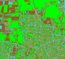
Research in the Remote Sensing Laboratory currently aims to advance the science of peri-urban environment impact assessment by developing a multi-source integrated and fused remote sensing data system. The system is expected to enhance the study of industrial pollutants and environmental monitoring.
The team is also developing a smart (optimized) irrigation system for farmers that includes a web-based decision support system (webDSS).
Both projects are funded by the Israel Water Authority and by the Israel Innovation Authority under its Israel-Italy Joint Innovation Program for Industrial, Scientific and Technological Cooperation.
Related pages
Dr. Anna Brook researcher page